Beyond Visual Line of Sight (BVLOS) drone operations: Requirements, waivers, and connectivity solutions

Learn about Part 107 rules, technology and connectivity considerations, and the future of Beyond Visual Line of Sight (BVLOS) drone operations.
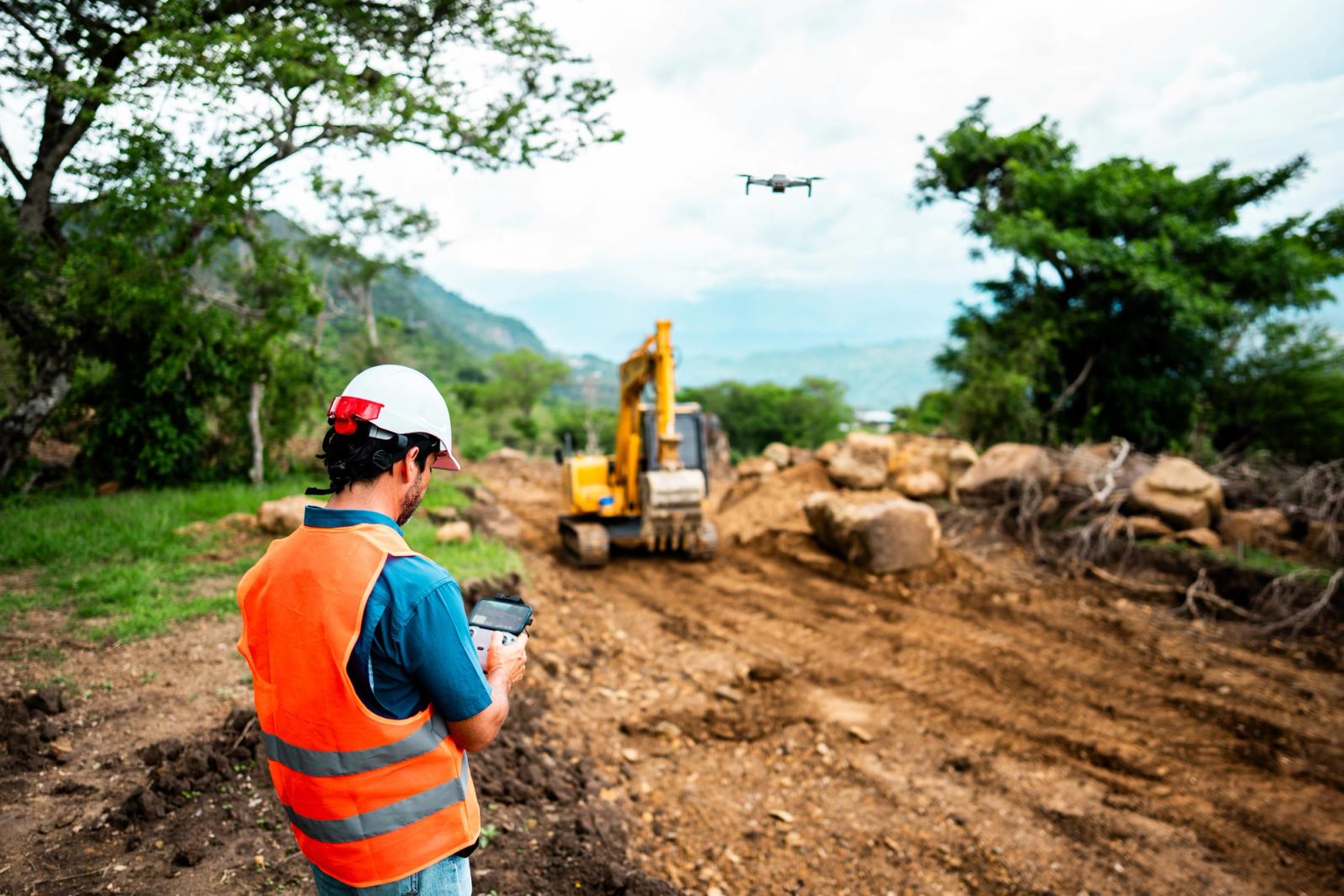
BVLOS (Beyond Visual Line of Sight) operations refer to drone flights conducted outside the pilot's direct visual contact with the aircraft. In the U.S., these flights currently require FAA authorization, typically through Part 107 waivers or other exemptions. The FAA has signaled intent to develop a new BVLOS regulatory framework (often referred to in industry discussions as a potential "Part 108"), but that rule has not yet been finalized or implemented.
This guide covers what BVLOS means, how it differs from standard visual line of sight operations, the regulatory pathway to approval, and the connectivity infrastructure that makes reliable beyond line of sight flights possible.
What is BVLOS and how does it differ from VLOS operations?
Beyond Visual Line of Sight (BVLOS) operations involve flying drones outside the pilot's direct visual range. In the U.S., these flights require FAA approval or waivers, though new regulations are under discussion to make routine BVLOS operations more accessible. Flying a drone beyond what you can see opens up possibilities that simply don't exist within visual range. Pipeline inspections covering dozens of miles, medical deliveries to remote communities, and agricultural surveys spanning entire farms all become practical when pilots aren't limited to keeping eyes on their aircraft.
BVLOS (Beyond Visual Line of Sight) for extended capabilities
BVLOS describes any drone flight where the remote pilot cannot see the aircraft with their own eyes. These types of operations are crucial for applications like long-range infrastructure inspection, package delivery, and surveying large areas, as they allow drones to cover significantly more ground than is possible with VLOS (Visual Line of Sight) flights. BVLOS operations are heavily regulated and require specific approvals and sophisticated technologies to ensure safety, including reliable communication systems and advanced sense-and-avoid capabilities.
EVLOS (Extended Visual Line of Sight) as a transitional flight mode
Extended Visual Line of Sight (EVLOS) is an industry term for operations where visual observers are used to extend how far an aircraft can safely be monitored using human eyesight. In some jurisdictions this is a formal category; in the U.S., Part 107 only defines a VLOS requirement for the remote pilot, and any operation where the pilot cannot maintain that VLOS typically requires a waiver, even if observers assist. Many U.S. operators experiment with EVLOS concepts under VLOS or waiver conditions as a stepping stone toward more advanced BVLOS approvals.
VLOS (Visual Line of Sight) as the current standard
VLOS is the opposite of BVLOS. Under VLOS rules, pilots maintain constant unaided visual contact with their drone throughout the entire flight. This means the pilot must be able to see the drone with their own eyes, without the help of binoculars, telescopes, or other visual aids. Standard Part 107 operations, which govern commercial drone use in the United States, assume VLOS. This is why flying Beyond Visual Line of Sight (BVLOS) requires extra approvals and waivers from the Federal Aviation Administration (FAA).
Typical VLOS limitations
Depending on aircraft size, lighting, and pilot eyesight, many operators find that small drones become hard to see somewhere on the order of 1,500–2,000 feet under ideal conditions. In practice, that range shrinks quickly.
- Weather: Fog, rain, and haze cut visibility dramatically.
- Lighting: Bright sun, deep shadows, and dusk all make tracking harder.
- Aircraft size: Smaller drones disappear from view at shorter distances.
- Terrain: Hills, trees, and buildings block the pilot's line of sight.
For commercial applications covering large areas or long distances, VLOS constraints become a significant bottleneck.
Why BVLOS matters for commercial drone operations
When you remove the visual line of sight constraint, drones can do things that were previously impractical. A pipeline inspection that once required a pilot to relocate every few thousand feet can now happen in a single automated flight covering miles.
Expanded range and operational efficiency
BVLOS allows one pilot to manage missions covering dozens of miles. The efficiency gains go beyond distance, too. Automated routes reduce human error, enable repeatable data collection, and let skilled pilots oversee multiple aircraft at once. This increase in operational scope fundamentally changes the economics of drone-based services, making large-scale data collection far more cost-effective. BVLOS capabilities open up possibilities for applications such as long-range infrastructure inspection and delivery services that were previously impractical.
Under VLOS, a pilot may have to reposition periodically, which can limit the efficiency of large-area surveys. BVLOS operations can substantially increase the area covered in a single mission, often allowing a single flight to map large fields or multiple adjacent parcels depending on aircraft endurance and regulatory constraints.
Industries driving BVLOS adoption
Beyond Visual Line of Sight (BVLOS) is expected to grow from USD 15.36 billion in 2025 to USD 25.32 billion by 2030 at a CAGR of 10.5% and is experiencing rapid acceleration across several key industries.
- Logistics: Last-mile package delivery and medical supply transport to remote areas.
- Agriculture: Crop monitoring, irrigation management, and precision spraying across large operations.
- Infrastructure: Power line, pipeline, and wind turbine inspection.
- Public safety: Search and rescue, wildfire monitoring, and disaster assessment.
Technology requirements for BVLOS drones
BVLOS operations demand more sophisticated equipment than standard drone flights. The technology stack covers navigation, obstacle avoidance, and reliable communication.
Sensors and navigation systems
Redundant GPS receivers provide primary positioning, while inertial measurement units (IMUs) track orientation. Many BVLOS aircraft use multiple navigation sources that cross-check each other for accuracy.
DAA sensors vary by application. Radar can detect other aircraft and obstacles independently of whether they carry transponders, while ADS-B or transponder-based systems detect cooperative aircraft that broadcast their position. Optical systems and lidar help identify obstacles and terrain features, especially at closer ranges.
BVLOS software and ground control stations
Ground control stations (GCS) serve as the pilot's interface to the aircraft. Modern BVLOS platforms display real-time telemetry, flight path visualization, and system health data.
Mission planning software lets operators define waypoints, set altitude parameters, and program contingency behaviors. Flight logs support regulatory compliance and operational analysis.
Command and control link specifications
The command and control (C2) link carries flight commands to the aircraft and returns critical telemetry. This link differs from payload data links that transmit sensor information like video.
C2 links require low latency and high reliability because communication failures create immediate safety concerns. For BVLOS waivers and certifications, the FAA evaluates proposed C2 performance (latency, availability, redundancy) against operational risk, often referencing industry standards and guidance documents rather than a single, fixed performance standard that applies to all operations.
Connectivity requirements for BVLOS drones
Connectivity often determines whether a BVLOS program succeeds. The communication link between pilot and aircraft carries real safety implications.
Why cellular outperforms traditional RF for beyond line of sight
For many small-UAS operators, consumer-grade RC links used for VLOS flights are not suitable for long-range BVLOS. In those cases, cellular connectivity can offer advantages:
- Existing infrastructure: In many populated areas, cellular networks provide wide coverage without requiring operators to deploy their own ground stations.
- Range: A cellular connection can maintain contact over the full planned flight path.
- Bandwidth: LTE and 5G can support both C2 and high-throughput payload data.
Specialized RF and satellite links are also used for BVLOS, especially in more demanding or remote operations.
Latency, throughput, and coverage specifications
For many small-UAS BVLOS operations, designers aim for C2 latency under roughly 500 milliseconds to support responsive control. More demanding operations may require lower latency, while highly automated or slower missions may tolerate higher latency, subject to FAA approval. Payload data has more flexible latency tolerances but higher bandwidth demands, especially for real-time video.
Coverage gaps present the biggest challenge. Rural and remote areas may have limited network availability, making carrier selection and redundancy important considerations.
Multi-carrier redundancy for mission-critical flights
Single-carrier connectivity creates a single point of failure. If that network experiences an outage or coverage gap, the aircraft loses contact with its pilot. Multi-carrier cellular connectivity addresses many coverage and outage risks by reducing dependence on a single mobile network operator. It removes one major single point of failure (a single carrier). Other failure modes like onboard hardware faults or complete regional outages must still be mitigated.
When evaluating connectivity providers, ask about failover time between carriers. Faster switching means less disruption to command and control.
Connectivity considerations for BVLOS OEMs
Drone manufacturers building BVLOS-capable aircraft face integration decisions early in design. Modem selection affects size, weight, power consumption, and certification pathway.
Planning ahead for growth is also an important design decision. SIM management becomes complex at scale. Platforms with robust APIs simplify fleet management, allowing OEMs to provision, monitor, and troubleshoot connectivity across deployed aircraft.
What are the FAA Part 107 BVLOS regulations?
The FAA's approach to BVLOS has evolved over time. Understanding both current rules and proposed changes helps operators plan their path forward.
Current FAA rules for beyond line of sight drones
Part 107, the main regulation for small UAS, requires visual line of sight by default. Operators who want to fly BVLOS apply for waivers under Section 107.31.
The FAA reviews each waiver application individually, looking at detailed safety documentation. Approval rates have improved as the agency gains experience, with 203 BVLOS waivers approved in 2024 representing 25% of all Part 107 waivers, though the process remains thorough.
The proposed FAA BVLOS rulemaking
Industry groups and FAA advisory committees have recommended creating a new BVLOS framework (often discussed under the working label "Part 108") that would provide a more structured path to authorization. Some proposals envision different tiers of operations, such as more streamlined processes for lower-risk flights (e.g., certain agricultural surveys) and more stringent requirements for complex missions like package delivery.
Other recommendations suggest allowing heavier UAS—potentially well above the current 55-pound Part 107 limit—to operate BVLOS under specific conditions. However, as of today, these concepts remain recommendations and discussion points; the FAA has not yet issued a formal BVLOS rulemaking that codifies a Part 108, the exact categories, or specific weight thresholds.
ADS-B and detect-and-avoid requirements
Detect-and-Avoid (DAA) technology forms the safety backbone of BVLOS operations. DAA systems use sensors to spot nearby aircraft and obstacles, then maneuver to maintain safe separation.
ADS-B (Automatic Dependent Surveillance–Broadcast) broadcasts aircraft positions to other equipped users and ATC. The FAA has defined ADS-B performance standards for manned aircraft and certain avionics, but for small UAS BVLOS operations, DAA and surveillance requirements are currently addressed case-by-case in waivers and exemptions. Future BVLOS rulemaking is expected to include more explicit performance criteria, but those rules are not yet finalized.
How to obtain a BVLOS waiver from the FAA
While the FAA has signaled its intent to develop a dedicated BVLOS rule in the future, waivers and other approvals remain the primary path to legal BVLOS operations today. A well-prepared application makes a real difference in approval chances.
BVLOS waiver application process
The process starts with submitting a Part 107 waiver application through the FAA's DroneZone portal. Applicants must provide detailed operational plans, risk assessments, and mitigation strategies as part of that online submission.
FAA evaluators evaluate whether the proposed operation maintains safety equivalent to standard Part 107 flights. They pay particular attention to how operators will detect and avoid other aircraft without visual contact.
Requirements for BVLOS certification and approval
FAA evaluators focus their efforts on reviewing the applicant’s concept of operations (CONOPS) and the operational hazard and risk analysis submitted by the applicant. A CONOPS should include a detailed description of the proposed operation, operational procedures, operational location, operational limitations, hazards, risks, and risk mitigations.
A risk analysis should include the severity of each hazard’s effect(s), likelihood of each hazard’s effect(s), risk mitigations, and predicted residual safety risk with all mitigations in place.
Successful applications typically demonstrate:
- Risk mitigation: Detailed hazard analysis with specific countermeasures.
- Pilot qualifications: Training records showing BVLOS competency and emergency response skills.
- Equipment documentation: Aircraft capabilities, maintenance procedures, and DAA system specifications.
- Lost-link procedures: Pre-programmed responses for communication failures.
- Airspace coordination: Plans for safe operation within the national airspace system.
The FAA provides in-depth information about the process and best practices for a successful application. Commercial firms, like Skydio, are also available that specialize in the waiver process.
Commercial use cases for BVLOS drones
Real-world BVLOS applications show what the technology can accomplish across industries.
Mapping & 3D construction data analytics
Industries like construction, mining, and waste management use Propeller to turn aerial images into detailed 3D maps.One example is tracking daily earthmoving production and operator efficiency in construction sites. Site managers can calculate precise volumes, measure distances, and monitor live machine telematics to reduce idle time and keep teams aligned. Users can overlay CAD and site layout designs directly onto the cloud-based map to allow seamless collaboration between field and office workers. By integrating live machine data through GNSS receivers like DirtMate, site managers can track cycle times and monitor equipment utilization in real time.
Package delivery
Matternet uses drones for ultra-fast, low-cost, and zero-emission deliveries for healthcare and commerce.Their home delivery service delivers lightweight packages to homes in Mountain View and Sunnyvale, California and even Dave’s Hot Chicken to hungry eaters in Los Angeles. To support these operations, the company relies on the world's only drone delivery system equipped with FAA Type Certification. This robust platform has already enabled them to safely complete tens of thousands of flights over cities across the US and Europe.
Public safety, asset inspection, and national security
Drone as First Responder (DFR) from companies like Skydio deploys drones to emergency scenes in under two minutes to provide police and fire services with instant situational awareness and better coordinated responses. The City of Fremont, California was an early adopter of a (DFR) Program and has found that drones can traditionally perform 33% of the missions that a traditional air support unit can perform at a fraction of the cost. They are also widely used by utility companies to safely inspect infrastructure like substations and stay ahead of power outages. Additionally, these drones serve national security purposes by providing real-time situational awareness, keeping combat teams out of harm's way.
Why reliable connectivity is the foundation of scalable BVLOS programs
BVLOS operations unlock transformative use cases across industries, but they depend on a robust and reliable communication infrastructure. Connectivity failures create safety risks and undermine regulatory compliance.
Multi-carrier cellular connectivity is one connectivity feature that addresses these challenges. Relying on multiple network providers removes the risk of a single point of failure. This approach ensures maximum uptime and resilience by seamlessly switching between available carriers.
As BVLOS regulations continue to mature and become more stringent globally, operators who proactively invest in highly reliable, multi-carrier connectivity infrastructure position themselves not only for immediate operational success but also for long-term compliance and competitive advantage as the industry scales.
What’s next for BVLOS?
BVLOS operations are fundamentally changing the potential of commercial drone applications by removing the restrictive visual line of sight constraint, enabling large-scale projects like long-range infrastructure inspection and high-efficiency delivery services. While the current regulatory environment requires individual FAA waivers, the industry is rapidly moving toward a dedicated framework that will standardize and accelerate BVLOS adoption. Ultimately, the successful and safe scaling of BVLOS relies on a foundation of sophisticated technology, with reliable connectivity serving as the critical link between the pilot and the beyond-sight aircraft.
FAQs about BVLOS drone operations
What latency is acceptable for BVLOS command and control links?
For many small-UAS BVLOS operations, designers aim for C2 latency under roughly 500 milliseconds to support responsive control. More demanding operations may require lower latency, while highly automated or slower missions may tolerate higher latency. Operators document their latency specifications as part of the waiver process.
Can commercial drone operators use cellular connectivity for FAA-compliant BVLOS operations?
The FAA has approved BVLOS operations that use cellular networks for command and control, typically under waivers or other specific approvals. Operators must demonstrate in their application that the cellular C2 link meets the necessary reliability, coverage, and performance requirements for their particular operation. It is not automatically approved for all use cases.
What happens if a BVLOS drone loses its connectivity link during flight?
Drones have pre-programmed lost-link procedures that activate automatically. Common responses include returning to the launch point, loitering until connection restores, or executing a controlled descent.
How do drone manufacturers integrate cellular modems for BVLOS operations?
OEMs select aviation-grade cellular modems that meet size, weight, and power requirements. They integrate SIM management for fleet operations and work with connectivity providers offering multi-carrier redundancy and developer-friendly APIs.
What is the difference between command and control links and payload data links in BVLOS operations?
Command and control links transmit flight commands and critical telemetry with strict latency requirements. Payload data links carry sensor information like video with higher bandwidth demands but more flexible latency tolerances.
How long does the FAA BVLOS waiver review process typically take?
Review timelines vary based on operation complexity and application quality. Preparing comprehensive documentation and engaging with FAA representatives early helps avoid delays.