Latin America's cities embrace tech to solve urgent urban challenges

From aerial cable cars to AI traffic systems, Latin America's tech revolution transforms urban life—building smarter, safer cities.
Intelligent transportation systems, advanced water management and early warning flood systems are just a few examples of how cities across Latin America are implementing smart technologies to address urban challenges and improve residents' quality of life. These initiatives demonstrate a commitment to creating more efficient, sustainable, and resilient urban environments across the region. This blog features innovative projects and their impact on cities throughout Latin America.
Guadalajara, Mexico: Water resource management
Belize City, Belize: Early warning systems
Panama Canal, Panama: Water quality monitoring
Mompox, Colombia: Smart city
Pindamonhangaba, Brazil: Flood monitoring
La Paz, Bolivia: Smart transportation
Santiago, Chile: Traffic management
Buenos Aires, Argentina: Smart meters
Guadalajara, Mexico: Water resource management
Guadalajara is located in the central-western region of Mexico, within the Atemajac Valley. Its topography is characterized by relatively flat terrain, although it is surrounded by hills and mountains, notably the Sierra Madre Occidental. Rainfall patterns in the city are variable, including intense wet seasons and prolonged dry periods, intensifying the effects of drought.
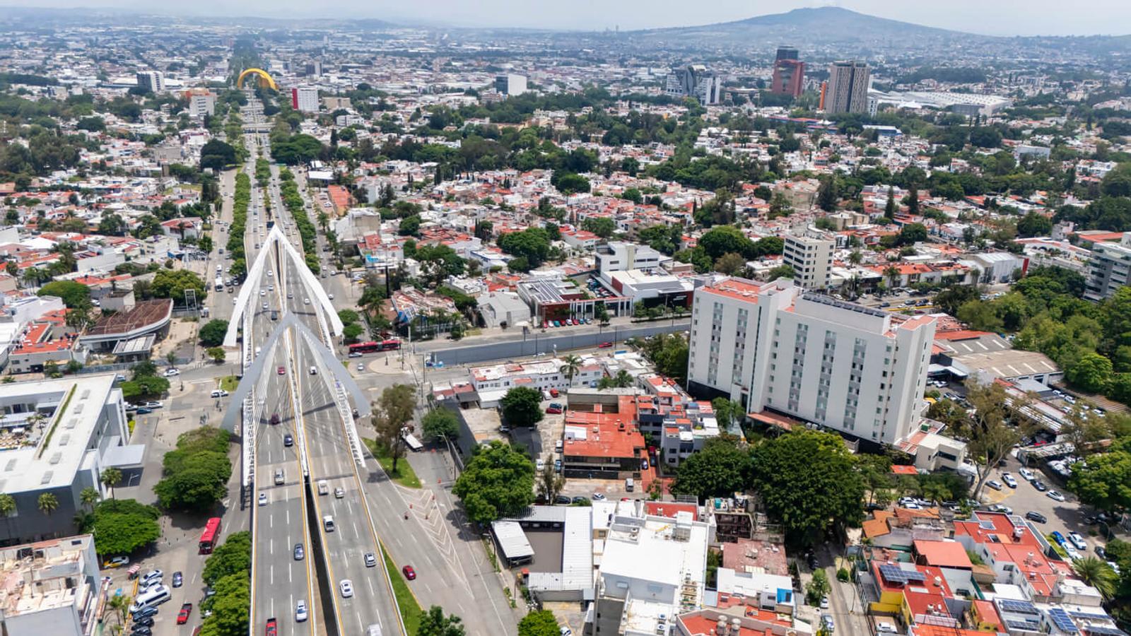
These environmental conditions, compounded by rapid urbanization, growing water demand, and increasing drought conditions, create significant water management challenges for Guadalajara. This leads to issues with water scarcity, inefficient distribution, and poor water quality as the city's current infrastructure often struggles with network losses and high energy consumption.
By digitizing the integrated water cycle the city is hoping to improve system efficiency, reduce energy consumption, and enhance overall water resource availability and quality. The program includes a large number of equipment and sensors to collect data in real time and provide the status of each of the systems that make up the integrated water cycle: collection and purification, supply, sanitation and purification. For example, these sensors are able to detect leaks to minimize water loss and provide real-time water level monitoring.
With this data, the city can comprehensively and efficiently manage water resource management, minimize the environmental impact on city resources and the larger Henares basin, and combat climate change. The initiative also provides transparency into water management to help with conservation efforts.
Belize City, Belize: Early warning systems
Belize City is located on a small peninsula at the mouth of the Haulover Creek, a tributary of the Belize River, which flows into the Caribbean Sea. Its low-lying coastal geography makes it particularly susceptible to flooding and storm surges.
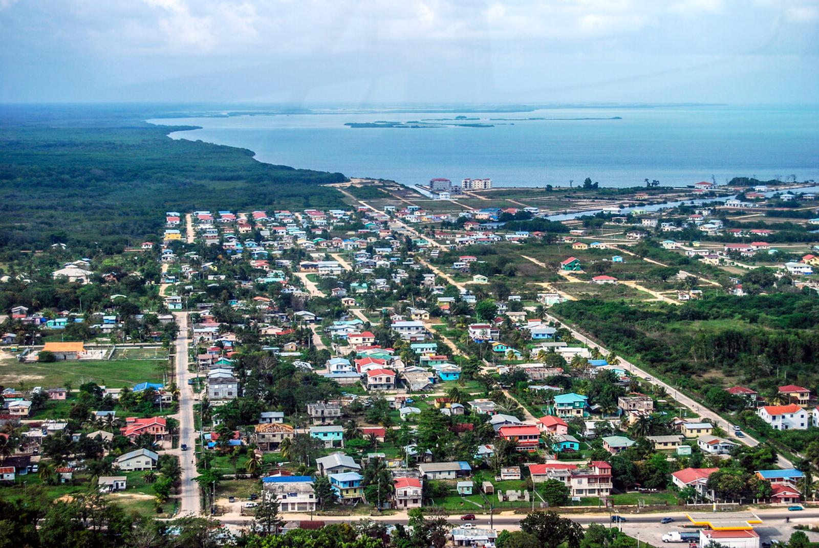
To help safeguard communities, the Belize Urban Resilience and Disaster Prevention Project has implemented a comprehensive flood early warning system. Their innovative system uses IoT-connected hydrological and meteorological monitoring stations and a network of sensors. Initially deployed in the vulnerable San Ignacio region, the system's reach has since been expanded to encompass the entire Belize River Basin, a critical area prone to significant flooding.
- Hydrological and meteorological stations: These stations collect real-time data on rainfall and river water levels in critical flood-prone areas. The continuous stream of data from these stations provides the information for accurate forecasting and timely alerts.
- IoT sensors: The sensors are the backbone of the system, tracking critical environmental parameters such as river levels and rainfall in real-time.The sensors send data to the Flood Warning Platform in real-time. The reliability and speed of this data transfer is key for effective disaster prevention and response.
- Flood warning platform: This system receives, processes, and visualizes the real-time sensor data,with visual charts, dashboards, and maps that display current water levels, rainfall patterns, and historical trends. This comprehensive overview enables decision makers to quickly assess the situation, identify potential threats, and predict the trajectory of developing flood events.
- GIS simulations: By integrating real-time hydrological and meteorological data with detailed geographical information, GIS simulations help model and analyze flood-prone areas. These simulations generate precise predictions of potential flood extents, depth, and flow paths, allowing authorities to identify at-risk communities and infrastructure.
- Automated warnings: A critical safety feature of the system is its automated warning mechanism. Pre-set thresholds for water levels and rainfall are configured based on historical data and expert analysis. When these critical thresholds are surpassed, the system automatically triggers immediate alerts. This rapid notification system ensures that emergency response protocols can be initiated promptly.
Panama Canal, Panama: Water quality monitoring
Each year, over 14,000 ships transport more than 200 million tons of cargo through the Panama Canal, highlighting its critical role in global trade. The Canal also serves as a vital source of drinking water for the surrounding communities. Gatun Lake, the main rainfall-fed reservoir that feeds the canal locks, provides drinking water to nearly half of Panama’s 4.5 million people.
Monitoring water quality within the canal is vital for detecting any changes or contaminants to provide clean drinking water. To help achieve that goal, the National Institute of Aqueducts and Sewers of Panama (IDAAN) is leading infrastructure digitization of the Canal. Via a large sensor network, the new water monitoring system collects critical data such as:
- Temperature: Helps assess climate change impact and detect anomalies affecting aquatic ecosystems and water treatment.
- pH and ORP (Oxidation-Reduction Potential): Indicates water acidity or alkalinity, key data for chemical treatments and contamination detection.
- Turbidity: Measures suspended particles, identifying sediment pollution and potential contaminants.
- Dissolved Oxygen: Essential for aquatic life and drinking water quality. Low levels signal harmful environmental conditions.
- Conductivity: Reflects dissolved salts and chemicals, useful for detecting saline intrusion or industrial discharges.
- Contaminant Detection (e.g., nitrates, oil, and pollutants): Enables early identification of illegal discharges, preventing ecological and public health risks.
With this new 24/7 monitoring system, contaminant spills in the Panama Canal can be detected early, helping increase rapid response to issues and maintain high quality of drinking water for the country.
Mompox, Colombia: Smart city
Mompox, a historic town in Colombia's Bolivar Department, attracts tourists for its vibrant culture, including the Mompox Jazz Festival and numerous film festivals. Its well-preserved colonial buildings and diverse architectural styles have earned the old part of Mompox recognition as a UNESCO World Heritage Site.

Now, this historic city is taking a big step into the future. Mompox is set to become the country’s first smart city through an investment of approximately $10.9 million USD. The project led by the Ministry of Information and Communications Technologies (MinTIC) in collaboration with regional and local governments, will transition Mompox into a modern digital infrastructure.
Key features include:
- Municipal Monitoring Center: This central hub will serve as the nerve center for coordinating actions with local authorities and security entities. It will operate on real-time information gathered from the new surveillance system, enabling proactive responses and enhanced public safety.
- Expanded fiber optic connectivity: Bridging the digital divide and ensuring equitable access to information, the project will establish 4,500 fiber optic-enabled internet points. This extensive network will significantly extend connectivity, reaching even the most remote and rural areas of Mompox, fostering greater inclusion and opportunities for all residents.
- Intelligent road system: To improve road safety and optimize traffic flow, Mompox will implement a 5-kilometer intelligent road that includes an IoT connected sensor network. This will enable Mompox to monitor road conditions, provide real-time information, and contribute to a safer driving environment for both residents and visitors.
- Smart urban solutions: The city's digital upgrade will also include EV charging stations and interactive screens across the city, providing valuable information and content.
- Environmental monitoring sensors: Mompox will deploy a network of sophisticated environmental sensors to continuously measure key indicators such as air quality, river levels, and water quality. This data will help local authorities to make informed decisions about environmental protections and sustainable development.
- Drone system: Leveraging advanced aerial technology, a drone system will be integrated into Mompox's smart city infrastructure. These drones will serve a dual purpose, enhancing public security through aerial surveillance and contributing to environmental monitoring efforts by collecting data on various ecological parameters.
This smart city initiative not only positions Mompox as a digital innovation hub in Colombia but also highlights the positive role of connectivity in economic development and quality of life improvements.
Pindamonhangaba, Brazil: Flood monitoring
Pindamonhangaba, a city located 98 miles from São Paulo, Brazil, has been facing increasingly severe climate-related challenges, particularly devastating floods. In December 2024, the city experienced an unprecedented deluge when 90 millimeters of rainfall occurred within a 24-hour period—equivalent to 74% of the previous month's total precipitation. The extreme weather event caused the Piracuama river to rise rapidly while the Una river overflowed onto connecting roads, destroying bridges and riverside homes.
In response to these challenges and risk to the population, Pindamonhangaba is accelerating its adoption of smart city technologies focused on climate resilience. The city has implemented a comprehensive network of 35 connected sensors strategically positioned throughout the municipality, with particular focus on vulnerable low-income areas.
These sensors continuously monitor environmental conditions including water levels and temperatures, functioning as an early warning system that automatically triggers alerts when dangerous thresholds are reached. High-speed connectivity is essential for transmitting this real-time data from the sensor networks to enable the immediate analysis and response to emerging threats. The system has already prevented more than 1 million reais in disaster-related costs.
Beyond flood prevention, the city is expanding its technological approach to address other climate-related challenges, including installing sensors in rural and mountainous regions for wildfire detection and exploring systems to monitor mosquito populations that spread diseases like dengue fever.
La Paz, Bolivia: Smart transportation
With a population exceeding 800,000, La Paz is the world's highest capital city at over 3,650 meters above sea level. It is part of the La Paz-El Alto metropolitan area, with a collective population of 2.8 million residents. El Alto is a rapidly growing city, home to one million people living at an altitude of over 4,000 meters.

An aerial cable car system, Mi Teleférico , connects more than two million people throughout the La Paz-El Alto metro area. Mi Teleférico is the world’s most extensive cable car transit system. Its ten lines span over 19 miles, creating a transportation network above the dense urban landscape. This system transformed the city, where congested streets, an under-resourced bus system, and challenging hilly terrain made commuting between neighborhoods inefficient, crowded, and unreliable.
The Mi Teleférico system has significantly boosted economic opportunities for El Alto residents. By offering affordable and efficient transportation, it connects them to jobs and markets in La Paz, with 440,000 commuters traveling daily between El Alto and La Paz for work.
The cable car system, designed to accommodate ten passengers per cabin, has station departures every 12 seconds, managed by smart technology. The design of the stations incorporates smart mobility technology, encompassing both software and hardware. This includes Passenger Information Systems for announcements, mobile applications, smart card ticketing, public address systems, telecommunication network coverage (including WiFi), fire alarm systems, biometric controls, electronic access gates, ‘smart point’ top-up machines, fiber optics, radio communication systems, internet, and CCTV systems.
Plus, to enhance energy efficiency, solar PV panels have been installed on every cable car, supplying electricity for internet connections, lighting, and communication systems. Within the stations, LED lighting has been implemented, leading to a 49% reduction in electricity consumption.
Santiago, Chile: Traffic management
Representing nearly 40% of the country's total population, Santiago, Chile's capital and largest metropolitan area, is home to approximately 6.8 million residents. Projections indicate that its population could exceed 7.5 million by 2033. This anticipated growth will place increased pressure on the city's infrastructure, particularly its transportation networks, which already handle over 18 million daily trips. The rise in both population density and vehicle ownership has prompted municipal authorities to find technological solutions to address urban mobility challenges before they reach critical levels.
In response, Santiago has unveiled a smart traffic management system that combines connected CCTV cameras with AI-enhanced traffic management capabilities. The system includes a total of 1,106 cameras across the metropolitan region, including 695 cameras in the commune of Santiago, 377 from the Operational Unit of Traffic Control (UOCT), and 34 from Central Station, the city’s main railway hub.
This system enhances the existing network managed by UOCT, which already oversees more than 3,000 traffic lights and 200 cameras throughout Santiago. Since implementation, the system has demonstrated impressive results, improving average travel speeds by 15% and reducing emissions by an estimated 20%.
- By integrating previously separate camera networks into one system, authorities can now coordinate responses to traffic incidents, emergencies, and security concerns with speed and efficiency.
- The AI capabilities enable automated monitoring of traffic conditions, quick identification of accidents or congestion points, and coordinated adjustments to traffic signal timings across the metropolitan region.
- This real-time response capability significantly improves daily commutes for residents.
- At the same time it enables faster emergency service deployment and more effective management of special events or unexpected situations that impact smooth traffic flow.
The integration of artificial intelligence into urban management systems positions Santiago as a regional leader in smart city implementation, demonstrating how technology can address multiple urban challenges simultaneously while creating a foundation for future innovations in city management and public safety.
Buenos Aires, Argentina: Smart meters
Buenos Aires, Argentina's capital and economic hub, faces unique energy challenges as it modernizes its infrastructure and reduces inefficiencies in its power grid. The metropolitan area is one of the largest electricity networks in the country, covering millions of users. Their traditional electricity meters and grid systems have struggled to manage growing urban energy demands.

The Argentine government has launched a significant push for smart meter deployment, with power regulator Enre playing a central role. The initiative involves a public-private working group tasked with implementing smart metering technologies in Buenos Aires, particularly within the concession areas of Edenor and Edesur. (A concession area in Argentina is a specific region or territory granted by the government to a private company for the exclusive right to develop and operate a public service or natural resource.)
Approximately 100,000 smart meters have already been deployed across rural and semi-urban areas. The government envisions a gradual phasing out of traditional meters by the end of the decade.
These smart meters, enabled by IoT connectivity, allow real-time monitoring, automation, and data collection to create a more dynamic and decentralized energy grid. They are expected to enhance grid efficiency by enabling features such as time-of-use electricity rates, which help balance demand and support distributed energy generation. Additionally, smart meters also improve the overall efficiency of the grid by enabling predictive maintenance and reducing operational costs.
The future of smart cities in Latin America
The smart city initiatives highlighted across Latin America represent more than technological upgrades—they highlight a fundamental shift in urban governance and planning. As these projects expand, several important trends are emerging that will shape the region's urban development:
- Regional collaboration and knowledge sharing is becoming increasingly vital. Cities like Pindamonhangaba are already working with national organizations like Brazil's CEMADEN to integrate local sensor networks with broader monitoring systems. This multi-level approach creates more comprehensive solutions while maximizing limited resources.
- Focus on climate resilience will continue to drive innovation, particularly as extreme weather events become more frequent and severe across the region. The early success of flood monitoring systems and water management initiatives demonstrates the tangible benefits of proactive technological investments.
- Accessibility and inclusion are central concerns as smart city development progresses. Bolivia's Mi Teleférico shows how thoughtful implementation can address socioeconomic inequalities by connecting previously isolated communities.
- Public-private partnerships can help finance and implement future smart city projects. Argentina's smart meter initiative involving power regulator Enre and private distributors illustrates how government oversight combined with private sector expertise can accelerate digital transformation.
By prioritizing practical solutions to real challenges faced by citizens, Latin American cities are demonstrating that truly "smart" urban development puts people and sustainability at the center of technological innovation.